Title and statement of responsibility area
Title proper
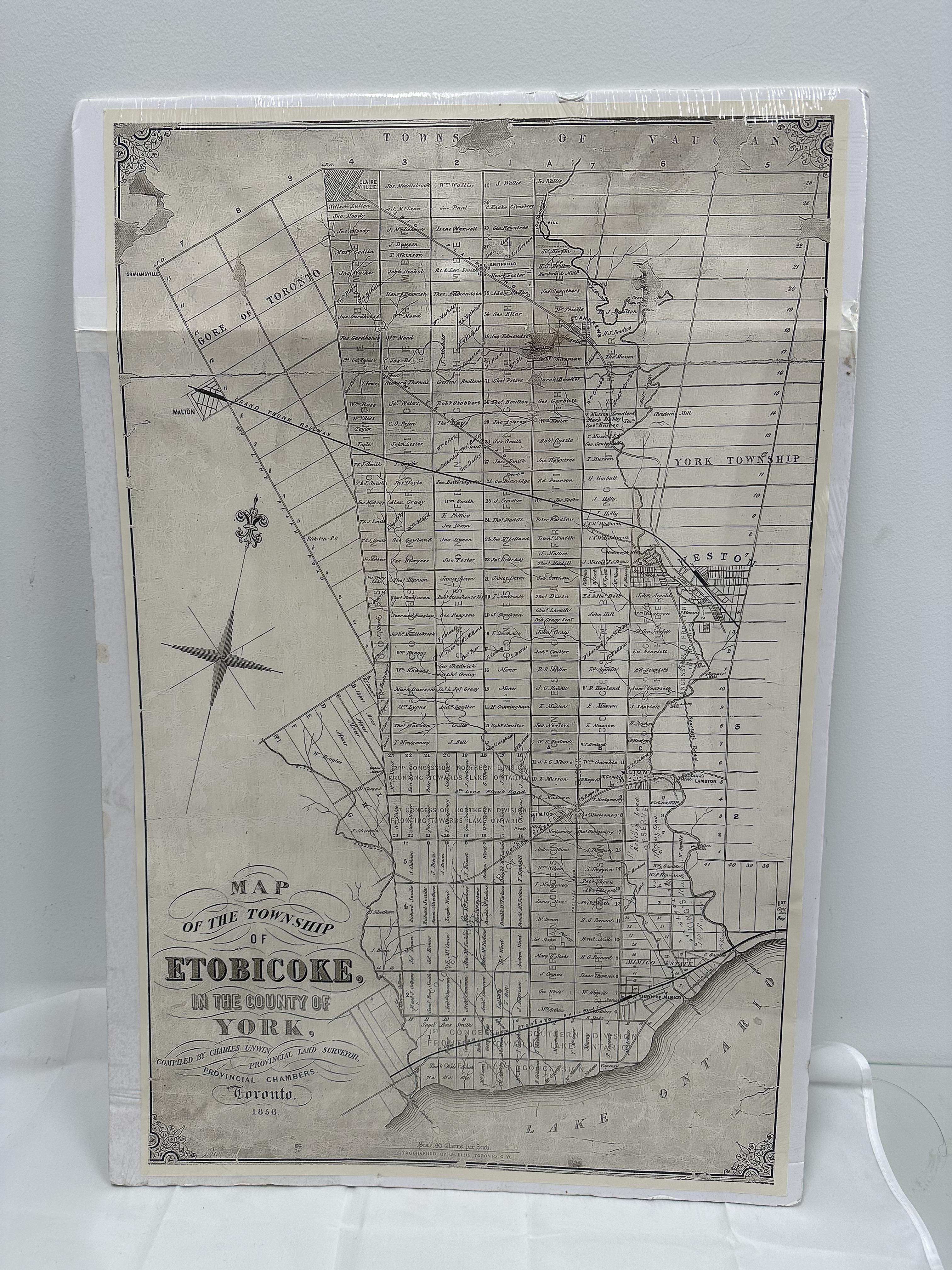
Map of the Township of Etobicoke, in the County of York
General material designation
- Graphic material
Parallel title
Other title information
Title statements of responsibility
Title notes
Level of description
Item
Repository
Reference code
Edition area
Edition statement
Edition statement of responsibility
Class of material specific details area
Statement of scale (cartographic)
Statement of projection (cartographic)
Statement of coordinates (cartographic)
Statement of scale (architectural)
Issuing jurisdiction and denomination (philatelic)
Dates of creation area
Date(s)
-
c. 2017 (Creation)
- Creator
- Lakeshore Grounds Interpretive Centre
- Place
- Toronto, Ontario, Canada
- Note
- Reprint date
-
1856 (Creation)
- Creator
- Unwin, Charles
- Place
- Toronto, Ontario, Canada
- Note
- Map maker
-
1856 (Creation)
- Creator
- Ellis, J.
- Place
- Toronto, Ontario, Canada
- Note
- Original printer
Physical description area
Physical description
REF.2023.004: Map
Publisher's series area
Title proper of publisher's series
Parallel titles of publisher's series
Other title information of publisher's series
Statement of responsibility relating to publisher's series
Numbering within publisher's series
Note on publisher's series
Archival description area
Name of creator
Biographical history
Name of creator
Biographical history
Name of creator
Biographical history
Custodial history
Scope and content
Vertical black and white illustration. The illustration shows the map of Etobicoke. At the bottom is Lake Ontario and above it is the outline of the Etobicoke borders. Within the borders, there are multiple vertical, horizontal, and diagonal lines dividing the area. Within most of rectangles/blocks there is a name and numbers. On the left side of the border, there is an eight-point compass and on the top of the border, there is a line of text. Below the compass there are a few lines of text. The illustrations has a border around the edge with swirls at the corners.
Notes area
Physical condition
Immediate source of acquisition
Arrangement
Language of material
Script of material
Language and script note
Mark / Inscription text: MAP / OF THE TOWNSHIP / OF / ETOBICOKE, / IN THE COUNTY OF / YORK, / COMPILED BY CHARLES UNWIN PROVINCIAL LAND SURVEYOR, / PROVINCAL CHAMBERS. / TORONTO. / 1856
Mark / Inscription type: Title
Mark / Inscription description: Curved lines around all of the rows of text
Mark / Inscription technique: Printed, black ink
Mark / Inscription position: On front, bottom left corner
Mark / Inscription language: English
Mark / Inscription translation: N/A
Mark / Inscription text: LITHOGRAPHED BY J. ELLIS TORONTO C. W.
Mark / Inscription type: Maker mark
Mark / Inscription description: Line above
Mark / Inscription technique: Printed, black ink
Mark / Inscription position: On front, bottom centre
Mark / Inscription language: English
Mark / Inscription translation: N/A
Location of originals
Availability of other formats
Restrictions on access
Terms governing use, reproduction, and publication
Finding aids
Associated materials
Accruals
Alternative identifier(s)
Standard number area
Standard number
Access points
Subject access points
Place access points
Name access points
Genre access points
Control area
Description record identifier
Institution identifier
Rules or conventions
Status
Level of detail
Dates of creation, revision and deletion
Language of description
Script of description
Sources
Digital object metadata
Filename
REF.2023.004_-_front_1.jpg
Latitude
Longitude
Media type
Image
Mime-type
image/jpeg